
There’s holes in them thar hills. And there’s very little left of Lesser Garth in Morganstown. An autumn afternoon’s adventure that proves to be an education and involves a hole of biblical proportions.
At the far end of the Ty Nant pub car park, before some allotments, there’s a footpath running perpendicular to the road up into the trees of Lesser (or Little) Garth hill. The footpath takes a left and runs along the back of the allotments, gently climbing but mainly following the map’s contours.
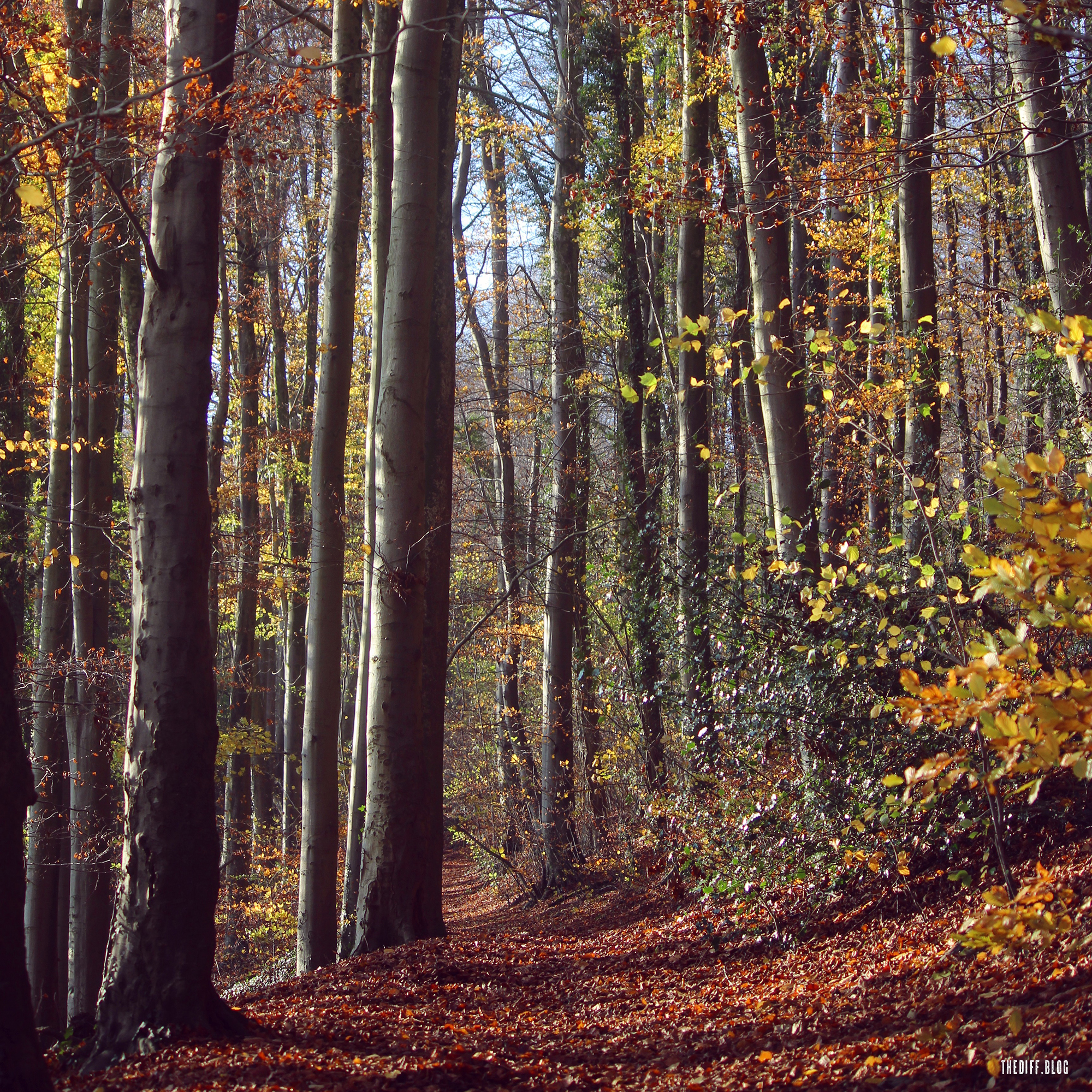
It’s a visual feast on a gorgeous November afternoon: autumnal colours stark against a cobalt blue sky, a rusty red carpet climbing up through the dark pillars of ancient beech, and golden light from the dipping western sun catching the more stubborn, lingering leaves. The constant industrial hum of the nearby M4 aside, it’s comforting to consider that this spot hasn’t changed much in centuries.
This is the southern perimeter of Cardiff Beech Woods – 114 hectares of some of the best ancient beech forests in the UK, apparently, and a Designated Special Area of Conservation (SAC) and protected under European Union law as a Natura 2000 site (not that the latter will mean much soon).
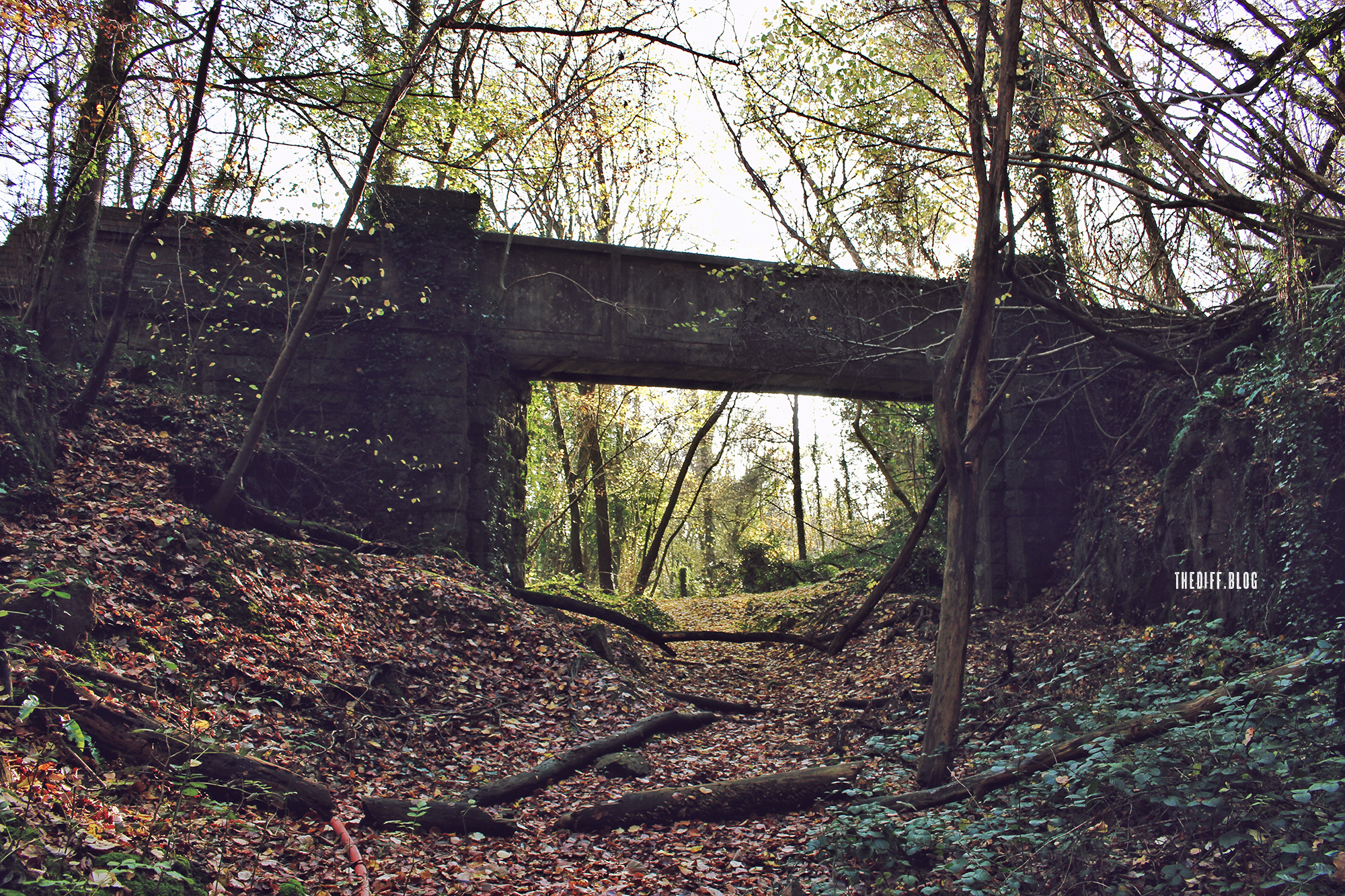
But all is not quite what it seems. After a while the path crosses a small ravine by way of a decidedly out-of-place, narrow concrete bridge with high sides intended to prevent you from peeking over. But peek over you invariably do to look down upon a large blocked-up tunnel entrance. This was a rail line. This wood wasn’t always so quiet.

I clamber down for a better look at the portal of what I later discover is the Garth (or Walnut Tree) Tunnel, a 490-yard long remnant of the Barry Railway line’s Rhymney branch, from Tyn-y-Caeau Junction (near St Fagans) to Penrhos Junction (near Caerphilly), which opened in 1901 and fell permanently silent on 31 March 1963. It’s hard to believe that dirty, noisy trains bustled through here.

On the other side of the hill, the line spanned the valley at Taff’s Well by way of the Walnut Tree Viaduct that stood for 70 years before its removal in the early 1970s when the new A470 was constructed. (The image below by John Bulpin is one of a collection that can be seen on his Flickr, here.) Today all that’s visible down in the valley is a huge monolithic brick pier with JUBILEE 2012 (originally 1977) painted on it for some reason. There’s a good little article about the viaduct by Living Mags here. And Kris Carter has lots of photos and a good description of its decline and demolition on his blog, here.

Only last week when making a delivery of a few framed prints to a business in Taffs Well did I once again see that large brick pier that stands close to the Taff and made a mental note to find out more about it…and didn’t bother. But now at last, thanks to this ramble, I have.

What lies beneath
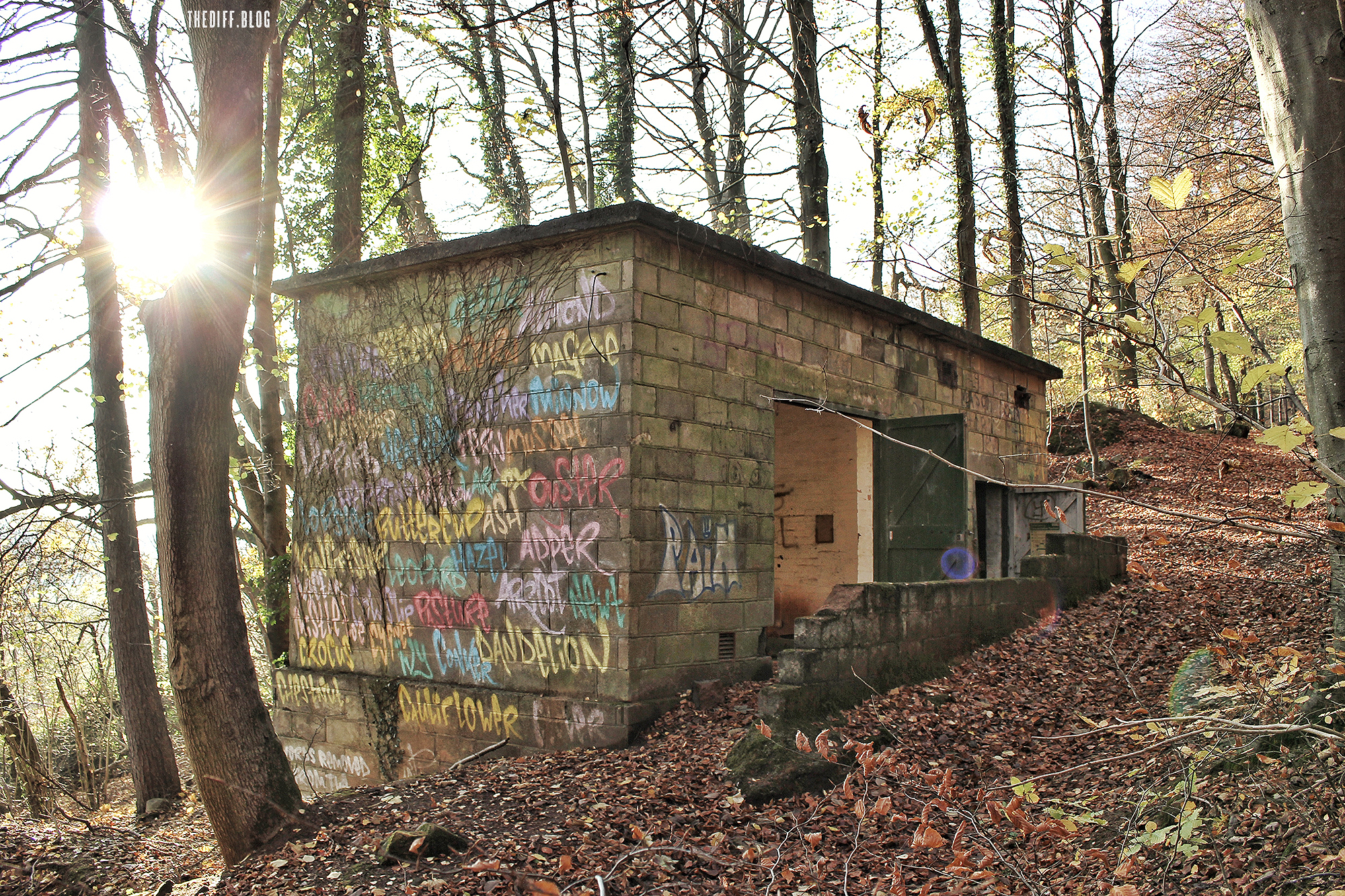
This portal on Lesser Garth hillside wasn’t always so well blocked up as it is now, but a new access tunnel into the vast Steetley Dolomite quarry, owned by Cemex since 2004, that lies beyond this hillside facade breached the old railway tunnel, so it’s become a site security risk. Opened in 2009, the two-lane road tunnel into the quarry’s southeast corner was expected to extend the quarry’s working life by a couple of decades. So one more to go then…
The tunnel is a reminder of what lies beneath (or inside) in these parts – as well as the area’s mining past (and present). Like Garth Mountain to the north and the hillside above Castell Coch and Tongwynlais on the other side of the valley, 210-metre-high Lesser Garth has been the site of mining and quarrying for millennia; the Carboniferous Limestone ground abounds with myriad tunnels, mines and caves. Exciting!

Which reminds me… Once, when we were walking up the Garth from the Gwaelod-y-Garth Inn we met a senior but energetic fella who claimed to sleep rough in the summer months on the hillside when not house-sitting for locals. He was eager to educate us so he walked with us up the mountain. Being wholly ignorant of the area’s past, we were more than happy for him to be our tour guide. However, his credibility wavered in our eyes when he claimed to only watch TV in friends’ houses to “check the shares on Bloomberg”. Understandably, I reckon, we weren’t sure if he was pulling our leg.
Anyway, seemingly in the middle of nowhere, halfway up the Garth, we passed some old stones and he claimed they’re what remained of the two-storey pub, the Colliers Arms, and Garth Hill House next to it. Really, we thought? I had my doubts, to be honest. Out here in the quiet and with no roads was a thriving venue, packed full of miners? Well, as it turns out, it’s true. The area is littered with clues to the industrial past.
This is also the case on Lesser Garth, the site of the Garth Iron Mine (1805–1884, 1926-1937). On the Welsh Mines Forum, the late Reg Malpass wrote: “The workings of the four main entries commenced at the surface and progressed downwards following the haematite ore and could, therefore, be described as quarries, the extent of the workings eventually necessitated the linking-up of these below ground by a maze of caverns and staple shafts.

“Some of the caverns were eventually excavated to impressive dimensions – one being estimated to have been about 200ft long, 100ft wide and 70ft high – and not a support in sight. The overall depth of the workings in 1884, at time of abandonment, was approximately 400ft. The main pit was some 120ft diameter at the surface.”

I really recommend taking a look at industrialgwent.co.uk, by Phil Jenkins. The website has photos of many of the overgrown, hidden features and relics of the area’s mining past, as well as recent images from inside the southern workings of Garth Iron Mine, like the two above.
Going underground
Nature was the original miner. On the south-facing hillside high above the Tynant Inn is Lesser Garth Cave, also known as Ogof Tynant. It features huge chambers (and a few very tight squeezes) and has been subject to human use for millennia, possibly at one time as a burial chamber. It was only rediscovered in 1912 by a Mr TE Lewis of Morganstown, according to Twixt Chain and Gorge (1991) a history of Radyr and Morganstown by the New Horizons History Group. (This publication is no longer in print but can be downloaded for free here.)
The cave joins up to another, Ogof Ffynnon Taf, discovered in 1986, making it – at 400metres in length – the largest cave system in the area.
(It’s strange when you think about it – underground on this hillside means hidden caverns lie high above the city below.)
So impressive are Brendan Marris’ photos from the caves, two of which are shown here, that they can be found on the Daily Mail website. Don’t worry, I won’t provide a link to that site. You can see all of Brendan’s images on his Caves of South Wales (ogof.org.uk) website, here. There’s a video too which conveys the tight squeezes very well – just watching it, I was panicking and perspiring on behalf of the jovial but fairly wedged cavers.

Archaeological excavations in Lesser Garth Cave in 1912-13, 1922 and 1963-4 discovered 209 human bone fragments from up to seven individuals. Though poorly documented, everything those digs turned up is now with the National Museum.
In 2016 five skeletons were able to be radiocarbon dated by a team from Cardiff University and the Cardiff Archaeological Society. They were found as having been living and breathing Cardiffians (well, humans anyway) between the 5th century and 17th century. No dates/lifetimes overlapped. Early Bronze Age artifacts also found in the cave included a brooch-pin, possibly of Irish origin.
There’s lots more in-depth information about the findings in Illuminating Lesser Garth Cave, a paper by Mark Redknap, Richard Madgwick, and Brian Davies, published in 2016 in volume 165 of Archaelogica Cambrensis. An online version can be found here.
Perhaps more important than dead people and their old pottery is the fact that the cave is presently one of only two UK homes of the rare blind cave spider (which is not to suggest it flits between the two, using Garth Cave as a weekend getaway or anything).
“We fitted a locked grille over the cave entrance to protect the spider’s habitat while leaving access for the greater and lesser horseshoe bats that roost there. Bees are also resident at the site,” says Cemex, the Mexican mining firm that owns the land and the monster quarry on the other side of this hill.

The abyss
Where once there was a hilltop that comprised more of Garth Wood, and beneath it a complex network of mines and caves, now there is a void. A big hole.
Known variously as Taffs Well Quarry, Walnut Tree Quarry, or after previous owners Steetley Dolomite, and now sometimes named after new owners (since 2004), Cemex, it’s Cardiff’s last working quarry. And it’s bloody huge.
Over the past few decades Swiss cheese-like Lesser Garth has been hollowed out. Annually, Cemex removes a million tonnes of aggregate, used in construction and road building.
Looking at Google Maps on my phone, the quarry is just the other side of this hill so I decide to try to take a peek. I want to view the hollow mountain for myself.
I half expect a fence or at least a warning sign but there is nothing but a thicket and a dumped red metal empty box. After a clump of bushes on a steep bank…nothing. A bald hill of groomed earth. It’s a bit moon-like, not that I’ve been. At the top, it’s breezy, exposed. The low sun casts long shadows. To the east the quarry lies still. Vast.

Click here for the gallery
Cardiff lies in the distance. It’s amazing, the proximity to people’s cosy homes and bustling everyday life, this huge site. I decide to view it from the south side so return to the footpath and head back eastwards before climbing up above the closed railway portal diagonally through the beech trees to try to stop from slipping or having a heart attack.

I finally reach the edge. What a view. I can see why the breeding peregrine falcons choose to nest on the rock face. (According to its website, Cemex uses new blasting methods that “leave a rougher surface that provides suitable nesting sites for the birds”.) As the sun drops, it’s eerily quiet. It’s not a thing of beauty, that’s for sure, but it’s awe-inspiring. In fact, it’s spectacular.

Click here for more photos of the Quarry
Due to the hill’s steep and slippery incline, the danger posed if you happen to be above the railway portal which isn’t fenced off, and of course the sheer drops at the edge of the quarry itself, the decision to leave the path in this area should not be taken lightly. It is private land. Basically, on your own head be it. Thanks for reading.

My son went a caving up there a few days ago. I had no idea it existed. Brilliant article. Looking forward to having an explore soon !
LikeLike
Thanks Tim. It’s a fascinating place. If you post or your son post any images or details of your adventures, please tag @ilovesthediff in or let me know here.
LikeLike